

June 6, 2018
The Kilauea volcano on the Big Island of Hawaii continues to erupt.
On Tuesday, a huge river of lava wiped out a neighborhood and filled Kapoho Bay.
Before-and-after satellite images released Wednesday show the scale of destruction in and around the ocean bay.
Reports suggest that hundreds of homes have been destroyed in the eruption event.
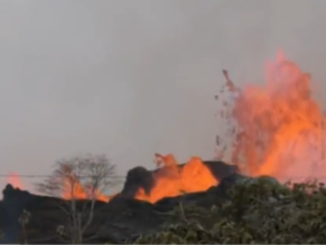
Hawaii’s largest volcanic eruption in years is on a destructive streak with no signs of slowing down.
The latest Kilauea eruption began on May 3 and has unleashed towering clouds of ash, hurled bombs of lava, and dumped rivers of molten rock into the tropical countryside, engulfing lush green landscapes and serene neighborhoods without discretion.
Most recently, the volcano sent a slow-moving yet enormous lava flow through the region of Pāhoa on the far-east end of the Big Island.
On Sunday, the flow crept toward Kapoho Bay, a roughly 1,000-foot-wide ocean retreat. By Tuesday, the lava flow had completely engulfed the bay and surrounding neighborhoods.
“Kapoho Bay is gone. Wiped out. Completely filled in with lava,” wrote Hawaii News Now. The outlet reported that hundreds of homes have been destroyed, including the second home of the Big Island’s mayor. Official counts peg the loss at about 200 structures demolished by the volcano since May, according to Reuters, though they will undoubtedly rise.
While the volcano brought its destructive power to Kapoho Bay, satellites watched the events unfold from space.
The following before-and-after images were taken by DigitalGlobe’s WorldView-2 Earth-imaging satellite and released on Wednesday.
“The difference between our June 3rd and June 5th images are dramatic, with lava completely filling Kapoho Bay by yesterday afternoon,” a spokesperson for the company said in a statement.
You can compare the images yourself using the interactive below. On the left is an image from Tuesday, which shows some areas already blackened by lava. On the right is an image from Sunday, which shows how much more damage was done in just two days.
Kapoho Bay was a special place that was filled with unique tide pools, locals say.
“It’s a beautiful spot,” resident Carolyn Boudreault the Star Advertiser on Monday. “Gorgeous.”
Source:http://www.businessinsider.com/hawaii-kilauea-volcano-before-after-satellite-pictures-2018-6


Be the first to comment